Watershed Development & Management
Watershed Development: Climate Adaptation for Resilient Communities
A watershed is a geographic region where all rainfall and surface water drain into a common outlet, such as a river or lake. When rain falls within a watershed, it flows downhill, collecting in streams and rivers. In many cases, rapid water movement prevents groundwater recharge, leads to soil erosion, and exacerbates the impacts of climate change, including droughts, erratic rainfall, and land degradation.
CIRHEP’s Climate-Resilient Watershed Development Approach
For over 20 years, CIRHEP has implemented climate-adaptive watershed management strategies to conserve water, restore ecosystems, improve soil health, and enhance climate resilience for rural communities. By integrating traditional knowledge with scientific techniques, CIRHEP is addressing the climate crisis at the grassroots level.
Key Components of CIRHEP’s Watershed Development & Climate Adaptation Initiatives
Water & Soil Conservation – Implementing rainwater harvesting, groundwater recharge structures, and erosion control measures to preserve water resources, prevent flash floods, and maintain soil fertility.
Sustainable Agriculture & Climate-Resilient Cropping – Promoting organic farming, drought-resistant crop varieties, agroecology, and water-efficient irrigation techniques such as drip irrigation to enhance food security and reduce climate vulnerability.
Livelihood Enhancement & Women’s Empowerment – Providing skill development, agroforestry training, and small-scale enterprise support, with a special focus on women and landless farmers to strengthen economic resilience against climate shocks.
Reforestation & Biodiversity Conservation – Restoring degraded landscapes through afforestation and agroforestry, increasing vegetation cover, reducing carbon emissions, and promoting biodiversity.
Community-Based Climate Adaptation – Training communities in climate-resilient water management, disaster preparedness, and sustainable resource use to build long-term environmental resilience.
Mapping Climate Adaptation Impact: The Musuvanuthu Watershed
One of CIRHEP’s flagship climate-adaptive projects is the Musuvanuthu Watershed, where scientific planning and community-driven interventions have led to:
Improved groundwater recharge, ensuring water security for agriculture and domestic use.
Increased soil moisture retention, reducing crop failures due to erratic rainfall.
Diversified income opportunities for women and farmers, strengthening economic resilience.
Enhanced forest and land restoration, mitigating climate-induced desertification.
Through integrated watershed management and climate adaptation, CIRHEP is building a sustainable and resilient future for rural communities in Tamil Nadu.
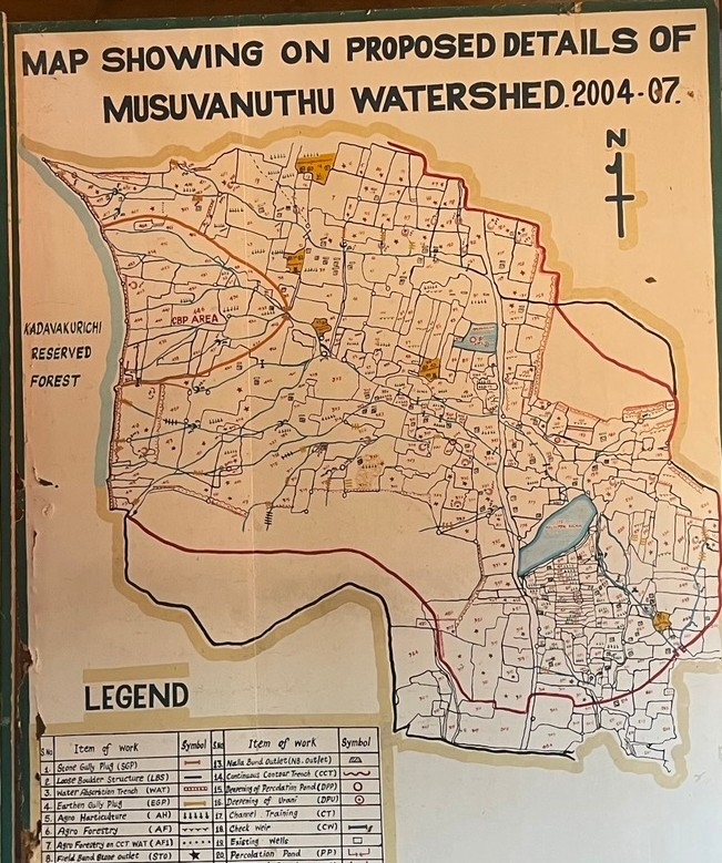
A watershed area is the geographic region, or catchment area where all the water drains into one common outlet, such as a river or lake. When rainfall occurs whitin the watershed the water flows downhill collecting in streams, rivers and other bodies of water, sometimes with high velocity, not letting the water percolate into the groundwater and taking away the top layer of soil.Watershed development and management refers to the comprehensive planning and implementation of strategies to sustainably manage the natural resources within a watershed area. It involves a range of activities aimed at conserving water, restoring ecosystems, improving soil health, and promoting sustainable livelihoods for communities residing in the watershed. The major components that has been put into practice by CIRHEP whitin these watershed areas for the last 20 years are: Water and soil conservation: measures to capture and store rainwater, improving groundwater recharge, and managing water Map showing the proposed details of Musuvanuthu Watershed resources efficiently within the watershed. As well as preventing soil erosion and protecting the soil’s fertility and structure.
Sustainable agriculture: Promotion of agricultural practices that optimize water use such as organic farming and drip irrigation to enhance productivity while minimizing environmental impacts.
Livelihood enhancement:
Capacity building, skill development, and promoting sustainable livelihood options such as agro forestry and small-scale businesses. Also with focus on women and landless empowerment and development
Reforestation: Planting trees and restoring vegetation cover in degraded areas to prevent soil erosion, enhance biodiversity, and improve overall ecosystem health.
Communtity participation: Active involvement of local communities in the planning, implementation, and monitoring of watershed development initiatives

Soil & Water Conservation
Many decades ago the area in the watersheds enjoyed a rich flora and fauna. The rainfall received percolated down into the groundwater and refilled the wells in the area. The farmers were cultivating rain-fed crops such as sorghum, millets and pulses.Climate change, deforestation and excessive groundwater exploitation are just few of the many root causes. The most affected by the ensuing water scarcity and the eight month dry period are the small and marginal farmers that do not get enough water to meet their needs. For the past 20 years, water and soil conservation programs have been a cornerstone of watershed development and management and CIRHEP’s organization , helping villagers and farmers to maximize their utilization of scarce water resources, as well as how to take care of the water that when it comes, comes in large quantities at the same time.
As part of this watershed development and water and soil conservation work CIRHEP has been conducting area and drainage treatments since 1994 . These initiatives focus on capturing and preserving water at the village level, guided by specially formed village watershed committees, with the ultimate goal of storing and conserving water where it falls. After completed construction of the watershed treatments the responsibility to maintain the watershed is left to the community watershed committee.

Area treatments Area treatments within a watershed area aim to target specific problems such as soil erosion with immediate and sustainable solutions such as planting trees. This approach allows for a more focused and efficient implementation of watershed management strategies.
Examples of area treatments are:
- Continuous contour trench (CCT)
- Water absorption trench (WAT)
- Field bund
- Summer ploughing Farm pondWell recharge pit
- Agro. forestry/horticulture Drainage treatments refer to the measures implemented to control and direct the flow of water and its surface runoff.This approach allows for optimixatiom of the water flow slowing it down and controlling its path as well as minimizing erosion and flooding.
Examples of drainage treatments are:
- Earthen/stone gully plug
- Loose boulder structure Gabion/earthen check dam
- Sunken pond Percolation pond Channel forming Check weir


Watershed development & management Water & Soil conservation ACHIEVMENTS
During the last 20 years
- Eleven watersheds completed and handed over with an area of 12,500 ha. and 50,000 residents in the drought hit area.
- Watershed committees, continued collaboration with all 11 watershed committee’s during and after finished project.
- Increased Ground water level the watershed activities applied such as area and drainage treatment has raised the groundwater lever from 150 to 300 feet
- Increased Environmental awareness, the constant involvement of villagers and the trainings and information provided by CIRHEP has guaranteed an increased environmental awareness in the area, from the creation and maintenance area and drainage of treatments to drip irrigation and household water conservation.
- Soil erosion controlled, watershed activities to protect soil erosion has been successful and soil erosion in the watershed is under control.
- Improved micro climate, all watershed activities has contributed to one larger goal which is the
- improvement of the climate.
- Reverse in migration trend, improvements in micro climate and increased ground water level has allowed for villagers who left due to water scarcity to return to their home village.
In summary, the completion of the eleven watersheds in the drought-hit area has increased groundwater levels, heightened environmental awareness, controlled soil erosion, improved microclimate, and resulted in a reversal in the migration trend. These achievements demonstrate the effectiveness of the watershed activities and the significant positive impact they have had on the communities and the overall environmental sustainability of the area.

